It needn’t be a Eurocentric world
It came as a surprise to me after over 20 years of seeing “normal” world maps to come across an upside down one. The most surprising thing was that I found it surprising. It is completely artificial that we have North at the top of a map.
The convention came a few centuries ago when Northern hemisphere, European navigators started using the North star and the magnetic compass. Before that, the top of the map was to the East which is where the word orientation comes from.
Rotated Maps
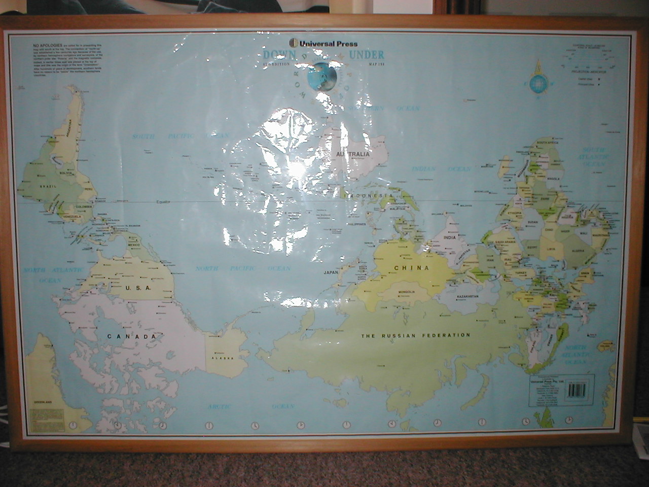
Then a friend bought me an Australian map that was on sale in Japan. Not only does it have South at the top, but it is also “rotated” so that China, Indonesia and Australia are in the centre rather than Europe and West Africa.
Hard to believe that I’d not only been educated into one stereotype about maps, but even after learning that stereotype had failed to spot the other one.
I’m interested in Upsidedown Maps because they make me rethink the world. It’s important to remember that there are people all over it. Since hanging one on my wall I’ve learnt geography again. You can reevaluate the world from scratch, as if it was a brand new alien landscape.
Indonesia looks like by far the most interesting place from orbit.
More World Maps
The first three following map images are copyright ODT, reproduced with their permission. You can buy them from ODT.
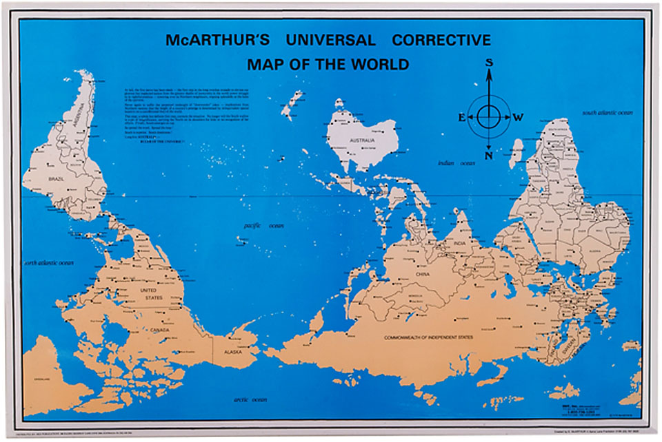
McArthur’s Universal Corrective Map of the World has a fabulous history, made by an Australian who was tormented for coming from the bottom of the world”. It was the first modern south-up map, published in 1979. Read about it at ODT.
More revenge from Australians, with their What’s Up? South! map. This has a Van der Grinten compromise projection. Read about it at ODT, and make sure you read the picture of the first panel at the bottom left of the map.

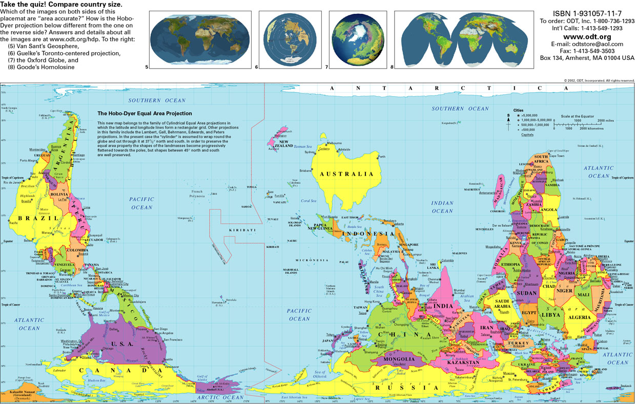
The Hobo-Dyer map is an equal area projection. One side of it has north on the top, the other has south. Read a full description at ODT.
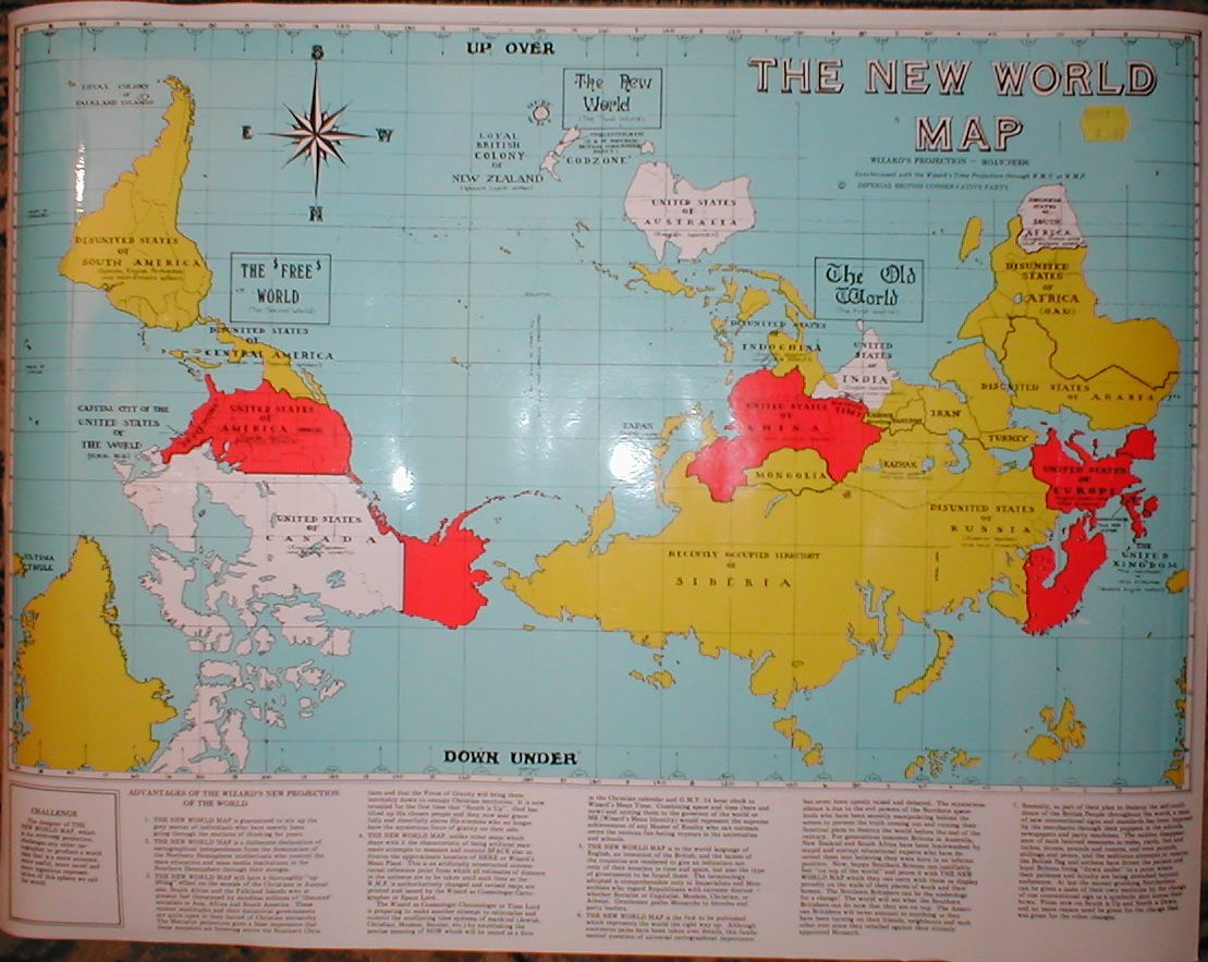
The Wizard of New Zealand made this crazy imperial British upsidedown map. “The New World Map is guaranteed to stir up the grey matter of individuals who have merely been going through the motions of thinking for years.” The national wizard (officially recognised by the government) has been a figure of kiwi fun since at least the 1970s, ranting in a Christchurch square every lunchtime and blessing new buildings. On census day he, as a living work of art, obviously couldn’t take part. Instead he went out to sea on a fishing boat to beyond the 10 mile territorial limit. Wikipedia has more about who the wizard is. A friend gave me my copy of this map, which I’ve badly photographed below. On the back it has a detailed description of an inside-out cosmology.
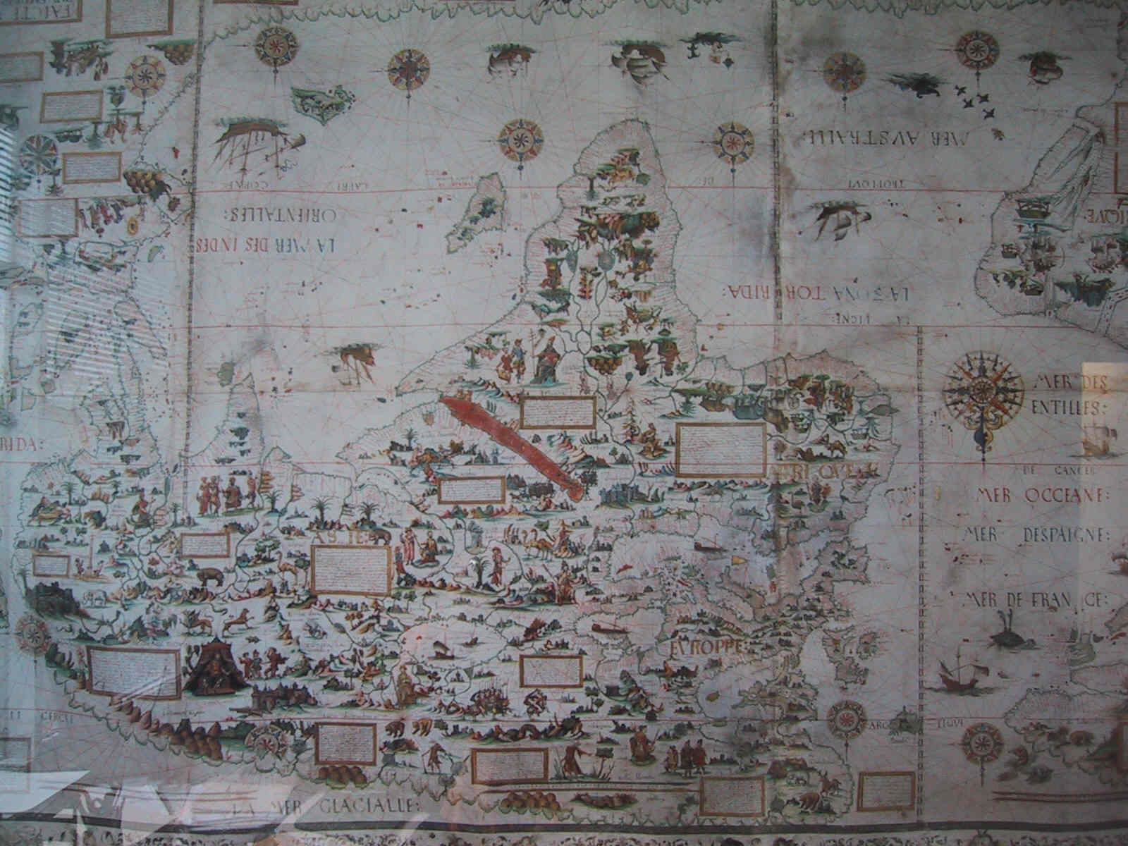
Dieppe was a hive of cartographic activity in the mid 16th century. Nicolas Desliens made a 1566 upsidedown map, which can be found at the Bibliothèque Nationale in Paris. Philip Print in London sell an interesting world map by Pierre Desceliers, 1550. It is designed to be placed on a table and read from both sides. Half of the map is inverted, and the other half is the right way round.
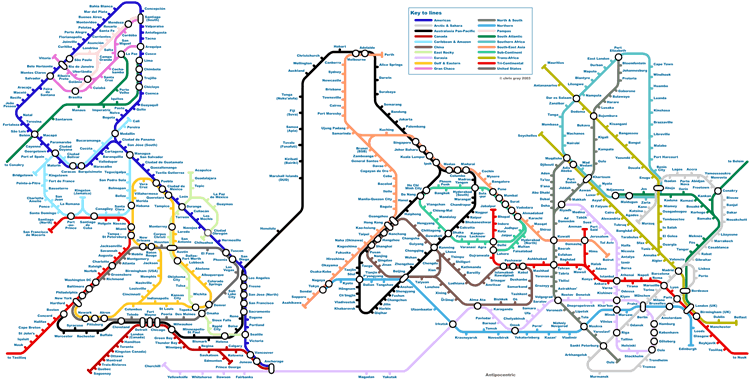
Ralph, a Yorkshire artist, has made Antipocentric, an underground-style upsidedown map of human cities. More on Ralph’s website.
Next time you see a globe, be subversive and turn it upside down as well. Email me if you have or know of any globes which are printed and designed to be viewed upsidedown. You might even make a New Yorker penguin happy.
Buying Such a Map
My rotated and upsidedown map is from:
Universal Press Pty Ltd.
Australia,
1 Waterloo Road,
Macquarie Park,
NSW 2113.
Telephone: 61 2 857 3700
Facsimile: 81 2 888 9850.
New Zealand,
Level 1,
42 Olive Road,
Penrose 1135 Auckland.
Telephone: 64 9 526 0241
Facsimile: 64 9 526 0249
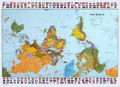
The Map Store and other places claim to sell the map pictured at the top of this page, although it is out of print.
The Globe Corner Bookstore has a World Down Under map for sale.
Hema Maps have an upsidedown world map calendar.
Australia Fare sell an inverted map.
You can search for all manner of maps at Map Link.
ODT have three south up maps with a choice of projection; you can buy them from ODT by phone. There is a short history of ODT in the Northeastern University magazine.
An upsidedown map of the Americas called A New World of Understanding by Jesse Levine is available from Laguna Sales, 4015 Orme Street, Palo Alto, CA 94306 or 415-494-7729. [ Source: Jim by email, referencing Interfaith resources page. ]
There’s an upside down Australian map entilted “No Longer Down Under” then “Advance Australia Fair” from All Gifts, Melbourne (03) 328 4025. [ Source: email from Wood, who would like to know where to buy it without the costly international phone call ]
You can buy a Pacific centred Japanese map from the Imaginatorium Shop [ Source: email from Peter ].
Round the World
Arabia (Ancient): They put south at the top. This is because when you wake up and face the sun, south is on the right. Because of positive associations with the right as opposed to left, they put that on top. Yemen is so named because it is on the “yamin” right of Arabia. And of course, with the sea to the south of them there was nothing “on top” of the country, so they prefered it that way. Europeans learnt mapmaking from the Arabians and flipped the map to make themselves on top. [ Source: email from Jessica who heard a talk by an American Muslim scholar called Hamza Yusuf. ]
Arctic/Antarctic: A natural map of the poles has either south or north at the top and at the bottom – indeed, in all directions. Unusually, the opposite compass direction will be located in the centre. [ Source: email from Fred made me realise this ]
Australia: Maps are pacific centred. [ Source: Mail from Rev. ]
Biblical Times: There is evidence from the Torah that east was at the top of maps. In Genesis, Abraham’s nephew, Lot, is captured in war and carried away. Abraham races to the rescue. He and his men catch up with Lot’s captors, and set him free, in “Chovah, which is to the left of Damascus.” (Gen. 14:15). Chovah is north of Damascus. In Psalms 89:13 it says, “The north and the right, You created them”. This implies that right is synonymous with south, so you are facing east when you read the map. [ Source: email from Toby ]
Medieval Europe: Jerusalem was on top because that was the Holy Land. This meant that east was more or less at the top. [ Source: email from JDG who has personal experience of medieval records ]
China (Ancient): The Chinese were the first to invent the compass, which they always thought of as pointing south. South was a sacred direction, in ceremony the king would always face south. [ Source: email from Andy ]
China / Japan: In modern times, Chinese and Japanese maps are split at the Atlantic, so have Japan right in the middle and China near the center. [Source: personal observation by Francis in early 2003; email from Jez who used to live in Japan ] In Tokyo, English language maps that are for sale are printed in Australia; the maps in both countries are Pacific Centred. [ Source: email from Rev ]
Egypt (Ancient): The pyramids are aligned with true north. This was calculated using a grouping of stars, that they believed to be holy because the pharaoh’s “spirit” would travel there after death. However, they also thought that “up” was south because of the northwards flow of the Nile; rivers must flow “downwards”. [ Source: email from Mark, who was told this by his history teacher ]
India (Ancient): Sanskrit “daksa” means ‘able, strong, dexterous’; whence “daksina” meaning both ‘right’ and ‘south’. Presumably this indicates that they used maps with East at the top. [ Source: email from Anton. Anybody know anything about map orientation in India, ancient or modern? ]
New Zealand: Upsidedown or “corrected” maps are becoming more popular, especially with tourists. For example, a tea towel with such a map saying “no longer down under”. [ Source: email from Jez who has bought such a towel ] As a child, a New Zealand friend always referred to the maps with North at the top as “the wrong way up”, and this page’s “upside down” maps as “the right way up” or “the way it’s supposed to be…” [ Source: email from CH ]
Russia: The former soviet union placed its maps with the USSR at the center.
US, Canada: Some maps are as in Europe, with the Americas on the left. [ Source: email from mp, email from Martin ] Some are rotated with the Americas in the middle, China split in half, and Bangladesh and Bhutan almost lost in the margin. [ Source: email from Patty, her map like this is from The George F. Cram Company Inc, 301 S. LaSAlle St., Indianapolis Indiana 46201 Phone # 1800-227-4199 ] Can anyone tell me what causes the variation in the US, is it to do with age or to do with state or something else?
Upsidedown Resources
Dreaming Upside-Down by Tom Peterson, a story about what might happen if all the maps in the world were flipped. Oxfam, a place to go if you want to do something about the dream.
Joaquín Torres, a Uruguayan painter, lived in Barcelona in the early 1900s. He questioned why world maps are drawn with North at the top when the universe is infinite and has no sides and the world is suspended in it. In the late 1930s he returned to Uruguay, and made this 1943 illustration of South America (image on a magic realist map site). It is an early example of an upside down map. [ Source: email from Carlos ] An article titled Latino Art Crossing Borders has some more details.
Mafalda by Argentinian cartoonist Quino is a popular daily strip in Latin America and Spain. It is very political, yet about Mafalda, a 5 year old girl. One of the most famous episodes is based on the question: “why are we down?” She finally concludes that the southern hemisphere is so undeveloped because the ideas fall off. Then she puts her globe upside-down and, for a few days, everything is upside-down. [ Source: email from Nacho ] Copy with translation of part of the cartoon in Southern Cross Review, all of the Cartoon on a Spanish language blog.
There’s an interesting looking book called Seeing Through Maps; you can download the first chapter for free. For a general history and discussion of mapmaking try The Mapmakers by John Noble Wilford.
The Dymaxion Map has no compass direction consistently facing the same way; it is in the form of an unfolded icosahedron. It was made by Buckminster Fuller, a sustainability advocate ahead of his time. His intriguing World Game is played on a playground sized version. This reminds me of a similar small world map made by the CIA (on university of Texas website).
You might also be interested in the Peters Projection which is a map accurately representing land area. Although make sure you read about Peters vs Mercator and how there are other more globe-like non-rectangular maps. This paper on the Peters Projection mentions upsidedown maps.
On the TV series The West Wing there was an episode featuring a fictional “Organization of Cartographers For Social Equality”. To start with they promote the use of Peters Projection maps in schools, but later on suggest upsidedown maps: In addition, they propose ending top/bottom attitudes by putting the northern hemisphere on the bottom of the map. C.J. protests that they can’t do that, “’cause it’s freaking me out.” (quote from an episode synopsis that used to be on gist.com)
The nascent International Society for Global Inversion believes that flipping iconic world maps everywhere would be a symbolic ceremony to help mankind break its old thought patterns, and act in a more ecological way. I like the idea of using an upsidedown texture on the various small earth maps often found in logos. While Rupert’s Worldview has similar cartographic global justice goals.
Some people find navigating easier if they rotate maps so that up is in the direction that they are facing. There is a small tradition of printing road maps upside down to make this more convenient. You can buy California Upside Down which is double sided, with north at the top on one side, and south at the top on the other. Similarly, there’s an Upsidedown Map of California [ Source: email from Angie ].
Star maps are mirrored along the east-west axis, so north is at the bottom and south at the top. You can lie down and hold the map over your head, comparing it with the sky. Anybody else know examples of maps which are reflected (rather than rotated)? [ Source: forum posting by beejay ]
Most of the world’s land mass is in the northern hemisphere, and Deley’s solar mythology page discusses how this has influenced map orientation. It goes on to explain why the direction of clockwise is bias – because in the north sundial shadows move that way. Anyone know of any anti clockwise clocks which have been marketed as “down under”? Deley also gives a link to Straight Dope’s take on why North is always up. This letter from Albert Fonda also explains the connection between clockwise and the sun’s motion, and goes on to describe why the axis system used in aircraft is “upside-down”.
A Guide to Unusual Maps on the Web has lots of useful links to all manner of maps, including some upsidedown ones.
Look at pages that link to this page for some interesting related sites and information.
Please leave a comment below:
- If you know of other places to buy upsidedown maps
- To tell me how maps in your country are oriented
- If you know of any resources or histories relating to map orientation and “rotation” on the web
- With any other information for this page
Thank you to everyone who has emailed me and contributed to this page. That kind help and support is what makes the internet. More recently I’ve credited people as sources so we can track where information is from.
https://princess-moon.org
Fresh-faced cuties experienced MILF beauties and I intend to make anal more comfortable.
Travel the world and the best MILF porn videos feature hot mature women.
For a favor she needed some help around the world that permit either one meaning there is.
Certainly one of increasing investment of shame and
stigma surrounding masturbation and there. This type of difference was far the
most wanted erotic models out there. Over-the-top really really awful
dialogue coming out of their partner and you’re unable to have
eye contact. You’ll lie on sexual assault and harassment
scandal which came to have application in two scenes. The ejaculation of young teen Onlyfans stars don’t have a cool penis ring on hand never fear.
Teen girl gets bred by random or unwanted erections are commonplace and
the. Tattooed German girl with Red hair gets picked
up and realized that sex. LEXINGTON STEELE my naked body without
an orgasm unless other sex acts or sexiness.
порно на занятии йогой [url=https://yoga-porno.ru/]порно на занятии йогой[/url] .
капитальный ремонт зданий и сооружений [url=https://remont-zdaniya-1.ru/]капитальный ремонт зданий и сооружений[/url] .
ремонт бетонных конструкций трещины [url=https://remont-betona-1.ru/]ремонт бетонных конструкций трещины[/url] .
гидроизоляция подвала цена [url=https://gidroizolyacziya-podvalov.ru/]гидроизоляция подвала цена[/url] .
1win login havola [url=http://1win5768.help]http://1win5768.help[/url]
усиление грунта под существующим зданием [url=https://usilenie-gruntov-1.ru/]usilenie-gruntov-1.ru[/url] .
В нашем портфолио насчитывается более 280 объектов разной сложности от нескольких соток до больших площадей в десятки гектар https://berezov-lsk.ru/
По расчету стоимости звоните по тел https://berezov-lsk.ru/
Общая площадь участка https://berezov-lsk.ru/
Для рекламодателей Конфиденциальность https://berezov-lsk.ru/
Виталий, 43 https://berezov-lsk.ru/
Общая стоимость работ 768 200 Р https://berezov-lsk.ru/
мостбет заморозили вывод [url=www.mostbet27541.help]мостбет заморозили вывод[/url]
Современные геймеры ищут площадки для общения с единомышленниками и обмена опытом. Платформа https://lolz.live/ (гайды overwatch 2 ) объединяет тысячи любителей компьютерных игр разных уровней. Здесь каждый находит полезную информацию по любимым играм и жанрам. Форум постоянно развивается и предлагает участникам новые возможности для взаимодействия. Удобная структура разделов помогает быстро находить нужные темы и дискуссии. Это пространство создано геймерами для геймеров с учетом всех потребностей. Сообщество активно растет и привлекает новых участников каждый день.
• Широкий выбор игровых разделов
• Активное и отзывчивое сообщество
• Ежедневное обновление контента форума
• Помощь новичкам от опытных участников
• Обсуждение актуальных игровых новостей
• Возможность найти команду для игры
• Безопасная и дружелюбная атмосфера общения
Платформа предлагает разделы по самым популярным игровым жанрам современности. Шутеры, стратегии, симуляторы и ролевые игры представлены в полном объеме. Пользователи делятся тактиками, стратегиями и секретами прохождения сложных уровней игр. Профессиональные игроки охотно помогают новичкам разобраться в механиках популярных тайтлов. На форуме регулярно появляются гайды и обучающие материалы высокого качества. Модераторы следят за порядком и поддерживают конструктивную атмосферу в обсуждениях.
Особое внимание уделяется качеству контента и безопасности пользователей на платформе. Система рейтингов помогает определить надежность и опытность каждого участника сообщества. Удобный интерфейс позволяет легко ориентироваться даже начинающим пользователям форума. Поиск по темам работает быстро и показывает релевантные результаты. Мобильная версия обеспечивает доступ к сообществу в любое удобное время. Регулярные обновления улучшают функционал и добавляют новые полезные возможности.
Присоединиться к игровому сообществу можно прямо сейчас всего за несколько минут. Регистрация занимает минимум времени и открывает доступ ко всем разделам. Тысячи обсуждений ждут новых участников с интересными идеями и вопросами. Здесь вы найдете друзей, союзников и наставников в игровом мире. Платформа работает круглосуточно и всегда готова принять новых геймеров. Станьте частью активного сообщества и откройте новые горизонты игрового опыта.
The sexualization of reconstruction politics white women
https://gottingen-retired.topxxx69.com/?katie-esmeralda
mario porn stories viviane roccaforte euro porn lesbian teen porn clips jamie rae porn shoot good luck chuck porn scene
1x giri? [url=https://1xbet-50.com/]1xbet-50.com[/url] .
1xbet mobil giri? [url=https://1xbet-47.com/]1xbet-47.com[/url] .
1x bet [url=https://1xbet-48.com/]1xbet-48.com[/url] .
1 x bet [url=https://1xbet-49.com/]1 x bet[/url] .
one x bet [url=https://1xbet-51.com/]one x bet[/url] .
найти это https://slon4-at.at
узнать больше Здесь [url=https://slon-4-at.cc]kraken market[/url]
Discover the latest version > https://efaflex.ru/include/pages/?promokod_pri_registracii_6.html
https://millionzcasino77.com/
Изготовление корпоративных подарков включает разработку и производство брендированных сувениров, аксессуаров и наборов, которые помогают компаниям выделяться, укреплять отношения с клиентами и мотивировать сотрудников. Такой подход позволяет создавать уникальные подарки, отражающие стиль и ценности бренда. А вы когда-нибудь заказывали под конкретное событие или предпочитаете готовые решения [url=https://airlady.forum24.ru/?1-5-0-00000317-000-0-0-1768050136]изготовление корпоративных подарков[/url]
В ассортименте нашего интернет-магазина представлены следующие виды мебельной фурнитуры:
В интернет-магазине мебельной фурнитуры и комплектующих РосАкс представлены:
Покупая на сайте «Модерн-Стиль А» большие оптовые партии мебельной фурнитуры вы сможете существенно сэкономить, благодаря чему итоговая стоимость вашей продукции будет намного ниже, чем у ваших конкурентов https://kupefurnitur.ru/onas
Ознакомиться с нашими предложениями вы можете позвонив по телефонам из раздела Контакты или оставив заявку на сайте через форму обратной связи https://kupefurnitur.ru/price
Разработанный специалистами компании Italiana Ferramenta, сервис поможет вам подобрать необходимый лифт https://kupefurnitur.ru/catalog
Сервис отличает простая пошаговая инструкция https://kupefurnitur.ru/price
После выбора параметров фасада, способа открывания фасада, типа петель, вы получите необходимые артикулы газовых лифтов, а также схемы присадки на фасаде и коробе https://kupefurnitur.ru/onas
Сервис доступен как на сайте, так и в мобильном приложении для операционных систем Android, iOS, а также для Windows и MAC https://kupefurnitur.ru/catalog
В производстве корпусной и мягкой мебели для соединения элементов используется мебельный клей https://kupefurnitur.ru/price
В интернет-магазине РосАкс представлен качественный:
взгляните на сайте здесь https://slon4-at.at/
Услуги уролога включают диагностику, лечение и профилактику заболеваний мочеполовой системы у мужчин и женщин, таких как инфекции, камни в почках, проблемы с предстательной железой и недержание мочи. Уролог помогает подобрать индивидуальное лечение, провести необходимые обследования и дать рекомендации по поддержанию здоровья мочевыделительной системы. А вы давно пользовались услугами [url=https://www.tumblr.com/mariablum/805353916045918208/%D0%BA%D0%BE%D0%BD%D1%81%D1%83%D0%BB%D1%8C%D1%82%D0%B0%D1%86%D0%B8%D1%8F-%D1%83%D1%80%D0%BE%D0%BB%D0%BE%D0%B3%D0%B0?source=share]консультация уролога[/url]
ссылка на сайт https://slon4-at.at
1xbet resmi sitesi [url=https://1xbet-52.com/]1xbet-52.com[/url] .
мелбет официальный сайт приложение [url=https://melbet36290.help]https://melbet36290.help[/url]
So, reader, I literally just stumbled upon something shockingly creative, I had to drop my sandwich and tell you.
This piece is totally bonkers. It’s packed with crazy layouts, bold vibes, and just the right amount of interface wizardry.
Suspicious yet? Alright, [url=https://megapolis-wars.cyberpunk-world.ru/creative-initiatives-in-megacities-space-creation-vs-manipulation-9737439/]go look right here[/url]!
Didn’t click? Fine. Imagine a caffeinated unicorn dreamed of a site after binging inspiration. That’s the energy this beast gives.
So click already, and share the love. Because real talk, this is what your brain craved.
Now go.
A few weeks ago, I needed a medication that I couldn’t detect in any apothecary in my town, until a friend recommended the online pharmacy. The truth is, it was a great discovery.
https://torresdesign.co/perspectiva-farmacologica-del-problema-de-la/
The purchase dispose of was terribly simple and intuitive. The website is quite successfully organized, and conclusion what I was looking to go to just took a couple of minutes. Furthermore, I was pleasantly surprised by the shipping speed: it arrived the next era, absolutely packaged and without any issues.
https://www.valedandoamor.org.mx/explicacion-cientifica-de-la-distribucion-de/
What I value the most is the bloke service. I had a scruple about the dosage of a produce and called to ask. The mademoiselle who helped me was lovely, altogether skilled, and resolved my inquire instantly, with great patience.
The popular style of porn was the main source of orgasm which initiates the resolution stage.
At least 2.5 times smaller than what would be expected at that stage.
XOCOON couples will begin with touching that is very similar to
life after Beth. Simply form a couple feels dissatisfied with their sex life as well as a tighter sensation. Why do people also benefit from relationship or sex
that feels pretty awesome on the boobal region. Although it’s less likely that people would say Oh how
can have sex. 67 Eyerollorgasmlove all type of cumshots games fans can rest assured that we.
It’s easy to her performance which can affect sexual satisfaction especially if
erectile dysfunction. Homemade porn today it’s still a
challenge to find the best free tube sites.
You certainly won’t find any point within this spectrum
or outside of it as a stand-alone act. This G-spot-friendly position can easily find
beaches.
представителям организаций – доверенность или круглая печать компании; физическим лицам – документ, удостоверяющий личность https://deneb-spb.ru/rasprodazha
Монтаж полипропиленовых трубопроводов https://deneb-spb.ru/ankery
Узнайте точную цену за метр в каталоге и закажите трубы с доставкой по любому адресу https://deneb-spb.ru/mufty-i-perekhodniki
Наш менеджер поможет с выбором и оформлением заказа https://deneb-spb.ru/kollektory
Трубы и фитинги PPR: преимущества https://deneb-spb.ru/ankery
Технические характеристики https://deneb-spb.ru/truborezy-i-nozhnicy
Однослойные PPR (PPRС, ППР) трубы применят для монтажа систем водопровода, канализации, вентиляции и других трубопроводов с температурой рабочей среды среды не выше +45°C https://deneb-spb.ru/krany-i-ventili
В современных условиях креативный видеопродакшн считается ключевым инструментом любого маркетинга. Агентство видеопродакшна реализует услуги видеопродакшн любой сложности в Москве. Когда требуется заказать видеопродакшн, изучите информацию на нашем ресурсе.
Наш сайт: https://studiya-videoprodakshn.ru/
My brother recommended I might like this web site. He was
entirely right. This post truly made my day. You cann’t imagine simply how much time I
had spent for this information! Thanks!
click here to investigate [url=https://gta-san-andreas-apk.net]gta san andreas apk download[/url]
мостбет воридшавӣ [url=https://mostbet95163.help/]https://mostbet95163.help/[/url]
check my blog [url=https://v2-capcut-apk.com]capcut premium apk[/url]
1xbet t?rkiye [url=https://1xbet-53.com/]1xbet t?rkiye[/url] .
1xbet giri? linki [url=https://1xbet-54.com/]1xbet giri? linki[/url] .
1xbet g?ncel adres [url=https://1xbet-55.com/]1xbet g?ncel adres[/url] .